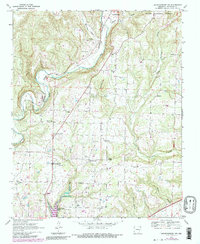
1969 Map of Mountainburg SW
USGS Topo · Published 1983About this map
Frog Bayou carves a path through the southern reaches of the Ozark National Forest in this survey of Crawford County. The landscape is defined by the valley of the bayou and the steep ascent of Winn Mountain, while the Northern Burlington railroad follows the water's edge. This map documents a transition in the local environment, notably the presence of Lake Alma at the southern edge. The distribution of small settlements and family-named landmarks like Dean Springs and Graphic suggests a rural community centered around agriculture and timber. Researchers will find a high concentration of genealogical sites, including the Hatfield Cem, Peters Cem, and Love Cem, alongside numerous country churches such as Gregory Chapel and the Baptist Ch that served these remote hollows.
Find a feature on this map
36 named features on this map. Tap any name to fly to it.
Don’t see what you’re looking for? This feature index may not catch every label — zoom into the map to look around manually.
Map Details
Editions of this 1969 Mountainburg SW Map
4 editions found
Other maps of this area

1879 · Fort Smith
USGS Topo · 1:62,500

1887 · Van Buren
USGS Topo · 1:62,500

1890 · Fort Smith
USGS Topo · 1:125,000

1898 · Winslow #4
USGS Topo · 1:62,500

1898 · Winslow #3
USGS Topo · 1:62,500

1898 · Winslow
USGS Topo · 1:125,000

1901 · Winslow
USGS Topo · 1:125,000

1906 · Lavaca
USGS Topo · 1:62,500

1943 · Fort Smith
USGS Topo · 1:125,000

1946 · Fort Smith
USGS Topo · 1:250,000