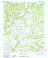
1969 Map of Mountainburg SW
USGS Topo · Published 1983About this map
Mountainburg and the winding course of Frog Bayou dominate this section of Crawford County, where the Ozark landscape begins to meet the developing valley to the south. The mapping reflects a transition period, with traditional rural landmarks like Winn Mountain and Little Mulberry Creek appearing alongside infrastructure like the Radio Tower and the expansion of Lake Alma. Small rural hubs such as Dean Springs and Mountain View are documented with their local institutions, including the Highway 71 Ch and Newberry Ch. Genealogists will find numerous family-named landmarks and resting places, such as Conley Cem, Hatfield Cem, and Peters Cem, which provide a geographic record of the area's established families during the late 1960s and early 1980s.
Find a feature on this map
38 named features on this map. Tap any name to fly to it.
Don’t see what you’re looking for? This feature index may not catch every label — zoom into the map to look around manually.
Map Details
Editions of this 1969 Mountainburg SW Map
4 editions found
Other maps of this area

1879 · Fort Smith
USGS Topo · 1:62,500

1887 · Van Buren
USGS Topo · 1:62,500

1890 · Fort Smith
USGS Topo · 1:125,000

1898 · Winslow #4
USGS Topo · 1:62,500

1898 · Winslow #3
USGS Topo · 1:62,500

1898 · Winslow
USGS Topo · 1:125,000

1901 · Winslow
USGS Topo · 1:125,000

1906 · Lavaca
USGS Topo · 1:62,500

1943 · Fort Smith
USGS Topo · 1:125,000

1946 · Fort Smith
USGS Topo · 1:250,000