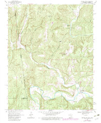
1969 Map of Natural Dam
USGS Topo · Published 1983About this map
The Indian Treaty Boundary cuts through the western edge of this landscape, marking a historical line of demarcation near the border of Arkansas and Oklahoma. The area is dominated by the ridges of the Ozark National Forest, where high points like Chinkapin Knob and Grapevine Knob overlook deep hollows. The namesake Natural Dam is situated along Lee Creek, which winds through the southern portion of the quadrangle past the small settlement of Independence. Cultural life in these hills is anchored by rural institutions, including Peaceful Home Ch and Independence Ch, along with several family burial grounds such as Bateman Cem and Morton Cem. A Lookout Tower and Radio Tower sit atop Liberty Hill, serving as modern vantage points over the older, established paths like the Jeep Trail and the remote hollows of Tom Jack Hollow and Huey Hollow.
Find a feature on this map
44 named features on this map. Tap any name to fly to it.
Don’t see what you’re looking for? This feature index may not catch every label — zoom into the map to look around manually.
Map Details
Editions of this 1969 Natural Dam Map
3 editions found

Other maps of this area

1898 · Winslow #3
USGS Topo · 1:62,500

1898 · Tahlequah
USGS Topo · 1:125,000

1898 · Winslow
USGS Topo · 1:125,000

1901 · Winslow
USGS Topo · 1:125,000

1901 · Tahlequah
USGS Topo · 1:125,000

1905 · Tahlequah
USGS Topo · 1:125,000

1946 · Fort Smith
USGS Topo · 1:250,000

1965 · Fort Smith
USGS Topo · 1:250,000

1967 · Fort Smith
USGS Topo · 1:250,000
1969 · Uniontown
USGS Topo · 1:24,000