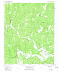
1969 Map of Natural Dam
USGS Topo · Published 1981About this map
Ozark National Forest covers much of this landscape along the border of Arkansas and Oklahoma, where the Old Indian Treaty Boundary marks a historical line between Crawford and Adair counties. The topography is defined by the winding course of Lee Creek and its many tributaries, including Mountain Fork and Cove Creek. Near the community of Natural Dam, the terrain features several family-named landmarks and local sites of interest like Hall Cem and Peaceful Home Ch. Further north, Liberty Hill and Grapevine Ridge rise above the valleys, while a Lookout Tower and Radio Tower sit atop the high ground near Ashley Hill. The presence of scattered cemeteries such as Bateman Cem and Morton Cem offers a record of early settlement patterns in this upland region, while the small community of Davidson is situated along the creek valley.
Find a feature on this map
39 named features on this map. Tap any name to fly to it.
Don’t see what you’re looking for? This feature index may not catch every label — zoom into the map to look around manually.
Map Details
Editions of this 1969 Natural Dam Map
3 editions found

Other maps of this area

1898 · Winslow #3
USGS Topo · 1:62,500

1898 · Tahlequah
USGS Topo · 1:125,000

1898 · Winslow
USGS Topo · 1:125,000

1901 · Winslow
USGS Topo · 1:125,000

1901 · Tahlequah
USGS Topo · 1:125,000

1905 · Tahlequah
USGS Topo · 1:125,000

1946 · Fort Smith
USGS Topo · 1:250,000

1965 · Fort Smith
USGS Topo · 1:250,000

1967 · Fort Smith
USGS Topo · 1:250,000
1969 · Uniontown
USGS Topo · 1:24,000