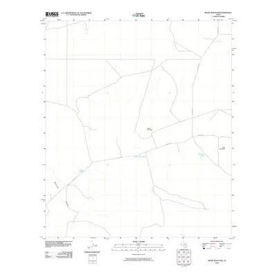
2010 Map of Movie Mountain
USGS Topo · Published 2010About this map
Movie Mountain rises above a desert landscape defined by ranching infrastructure and wide ephemeral basins in this West Texas survey. The terrain is centered on the local prominence of the mountain itself and nearby Seed Mountain, while the low-lying Blanca Flats stretch across the southwest. The human footprint is sparse but functional, centered on the Pierce Ranch and a network of essential water sources including Corner Tank, Horse Trap Tank, and Two Section Tank. These artificial tanks and simple dirt tracks like Big Tank Rd and Macado Rd illustrate the logistical realities of land management in Hudspeth County. The map provides a clear look at the distribution of these isolated landmarks and the vast drainage patterns that shape life in the Trans-Pecos region.
Find a feature on this map
9 named features on this map. Tap any name to fly to it.
Don’t see what you’re looking for? This feature index may not catch every label — zoom into the map to look around manually.
Map Details
Editions of this 2010 Movie Mountain Map
This is the sole edition of this map. No revisions or reprints were ever made.
Other maps of this area

1895 · Sierra Blanca
USGS Topo · 1:125,000

1948 · Triple Hill
USGS Topo · 1:62,500

1954 · Van Horn
USGS Topo · 1:250,000

1958 · Van Horn
USGS Topo · 1:250,000

1964 · Dome Peak
USGS Topo · 1:24,000
1964 · Bean Hills
USGS Topo · 1:24,000
1964 · Sierra Blanca
USGS Topo · 1:24,000

1973 · Norton Mesa
USGS Topo · 1:24,000

1973 · Sneed Mountain NE
USGS Topo · 1:24,000
1973 · Sneed Mountain
USGS Topo · 1:24,000