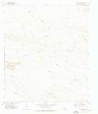
1973 Map of Sneed Mountain
USGS Topo · Published 1976About this map
Sneed Mountain and the Black Knobs define this arid landscape in Hudspeth County, where survival in the early 1970s was tied to a sophisticated network of water catchment systems. Scattered across the terrain are numerous named tanks, such as Berman Tank, Preston Tank, and Dagger Tank, which supported the livestock operations of the Reed Ranch and the G Mc Adoo Ranch. These features reflect the specialized ranching infrastructure required to manage cattle in the Trans-Pecos region.
Find a feature on this map
18 named features on this map. Tap any name to fly to it.
Don’t see what you’re looking for? This feature index may not catch every label — zoom into the map to look around manually.
Map Details
Editions of this 1973 Sneed Mountain Map
This is the sole edition of this map. No revisions or reprints were ever made.
Other maps of this area

1895 · Sierra Blanca
USGS Topo · 1:125,000

1906 · Van Horn
USGS Topo · 1:125,000

1954 · Van Horn
USGS Topo · 1:250,000

1958 · Van Horn
USGS Topo · 1:250,000
1964 · Sheep Peak
USGS Topo · 1:24,000

1964 · Dome Peak
USGS Topo · 1:24,000
1964 · Bean Hills
USGS Topo · 1:24,000

1973 · Norton Mesa
USGS Topo · 1:24,000

1973 · Sneed Mountain NE
USGS Topo · 1:24,000

1973 · Apache Peak
USGS Topo · 1:24,000