
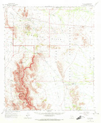
1963 Map of Mt. Ajo
USGS Topo · Published 1964About this map
The Papa Go Indian Reservation and Organ Pipe Cactus National Monument dominate this Pima County landscape, where the high peaks of the Ajo Range meet the desert floor. At the northern edge, the settlement of Schuchuli (Gunsight Com) sits near the Gunsight Cem and the Surprise Mine, reflecting the intersection of local community and early mineral exploration. The terrain is defined by dry washes like Gunsight Wash and Sikort Chuapo Wash that cut through the Gunsight Hills. To the south, the village of Gu Vo is supported by the Kerwo Day Sch, marking a primary social center for the region. Significant landmarks like Mt Ajo and the distinct formation of Montezumas Head provide navigational anchors in a territory marked by traditional O'odham place names such as Hotason Vo and Kavolik.
Find a feature on this map
63 named features on this map. Tap any name to fly to it.
Don’t see what you’re looking for? This feature index may not catch every label — zoom into the map to look around manually.
Map Details
Editions of this 1963 Mt. Ajo Map
2 editions found
Other maps of this area

1932 · Ajo
USGS Topo · 1:62,500

1934 · Ajo
USGS Topo · 1:62,500

1953 · Ajo
USGS Topo · 1:250,000

1954 · Sonoyta
USGS Topo · 1:250,000

1957 · Ajo
USGS Topo · 1:250,000

1958 · Ajo
USGS Topo · 1:250,000

1962 · Ajo
USGS Topo · 1:250,000

1963 · Ajo
USGS Topo · 1:250,000

1963 · Kom Vo
USGS Topo · 1:62,500

1963 · Ajo
USGS Topo · 1:62,500