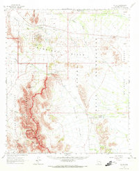
1963 Map of Mt. Ajo
USGS Topo · Published 1973About this map
Organ Pipe Cactus National Monument and the Papago Indian Reservation converge in this high-desert landscape, dominated by the peaks of the Ajo Range. The map documents a sparsely populated region where life centers on water sources like Barajita Well and Tonga Well. Human presence is marked by small settlements such as Schuchuli, Gu Vo, and Pia, alongside the Gunsight Cem. Evidence of mid-century mining persists at the Surprise Mine and Little Chief Mine in the Gunsight Hills.
Find a feature on this map
54 named features on this map. Tap any name to fly to it.
Don’t see what you’re looking for? This feature index may not catch every label — zoom into the map to look around manually.
Map Details
Editions of this 1963 Mt. Ajo Map
2 editions found

Other maps of this area

1932 · Ajo
USGS Topo · 1:62,500

1934 · Ajo
USGS Topo · 1:62,500

1953 · Ajo
USGS Topo · 1:250,000

1954 · Sonoyta
USGS Topo · 1:250,000

1957 · Ajo
USGS Topo · 1:250,000

1958 · Ajo
USGS Topo · 1:250,000

1962 · Ajo
USGS Topo · 1:250,000

1963 · Ajo
USGS Topo · 1:250,000

1963 · Kom Vo
USGS Topo · 1:62,500

1963 · Ajo
USGS Topo · 1:62,500