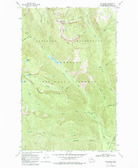
1969 Map of Mt Barney
USGS Topo · Published 1985About this map
Mt Barney stands as a prominent landmark in this high-altitude landscape within the Pasayten Wilderness and Okanogan National Forest. The map documents a complex drainage system where Black Lake and Dutton Lakes feed into various creeks including Andrews Creek, Disaster Creek, and Farewell Creek. This area, surveyed in the late 1960s, reveals the specialized infrastructure required for wilderness management, such as the Heliport and Gaging Station located along the water routes.
Find a feature on this map
33 named features on this map. Tap any name to fly to it.
Don’t see what you’re looking for? This feature index may not catch every label — zoom into the map to look around manually.
Map Details
Editions of this 1969 Mt Barney Map
2 editions found
Other maps of this area

1955 · Concrete
USGS Topo · 1:250,000

1958 · Concrete
USGS Topo · 1:250,000

1962 · Concrete
USGS Topo · 1:250,000

1962 · Mazama
USGS Topo · 1:62,500

1963 · Doe Mountain
USGS Topo · 1:62,500

1969 · Mt. Barney
USGS Topo · 1:24,000

1969 · Remmel Mtn.
USGS Topo · 1:24,000

1969 · Billy Goat Mtn
USGS Topo · 1:24,000

1969 · Ashnola Pass
USGS Topo · 1:24,000
1969 · Coleman Peak
USGS Topo · 1:24,000