
1942 Map of Mt. Boardman
USGS Topo · Published 1942About this map
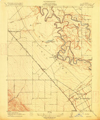
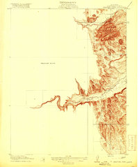
Mt. Boardman dominates the complex terrain of the Diablo Range where the borders of Alameda, Santa Clara, Stanislaus, and San Joaquin counties converge. This 1942 survey depicts an upland landscape of deep canyons and isolated holdings, such as Shanti Ashrama and the Livermore Dude Ranch. The region's early twentieth-century economy is visible through the numerous named family cattle operations, including the Wiesendanger Ranch, Schmidt Ranch, and Gerber Ranch, which are linked by unimproved roads winding through Arkansas Canyon and Blackbird Valley.
Find a feature on this map
53 named features on this map. Tap any name to fly to it.
Don’t see what you’re looking for? This feature index may not catch every label — zoom into the map to look around manually.
Map Details
Editions of this 1942 Mt. Boardman Map
This is the sole edition of this map. No revisions or reprints were ever made.
Other maps of this area

1897 · Mt. Hamilton
USGS Topo · 1:62,500

1907 · Tesla
USGS Topo · 1:62,500

1913 · Romain
USGS Topo · 1:31,680
1915 · Westley
USGS Topo · 1:31,680
1916 · Patterson
USGS Topo · 1:31,680
1916 · Romain
USGS Topo · 1:31,680

1917 · Morgan Hill
USGS Topo · 1:62,500
1919 · Orestimba
USGS Topo · 1:62,500
1919 · Orestimba Creek
USGS Topo · 1:31,680

1920 · Pacheco Pass
USGS Topo · 1:62,500