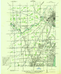
1936 Map of Mt Clemens
USGS Topo · Published 1936About this map
The Clinton River and its various branches, including the Middle Branch and North Branch, carve through this Macomb County landscape just before the mid-century suburban expansion. The city of Mt Clemens serves as the primary urban hub, while surrounding townships such as Erin and Warren are dotted with small settlements like Cady and Fraser. This 1936 survey, compiled from aerial photographs, illustrates a transition from rural drainage networks like the Kukuk Drain and Schulte Drain to the early leisure developments of the motor city era.
Find a feature on this map
109 named features on this map. Tap any name to fly to it.
Don’t see what you’re looking for? This feature index may not catch every label — zoom into the map to look around manually.
Map Details
Editions of this 1936 Mt Clemens Map
This is the sole edition of this map. No revisions or reprints were ever made.
Other maps of this area

1905 · Detroit
USGS Topo · 1:62,500

1905 · Grosse Pointe
USGS Topo · 1:62,500

1908 · Rochester
USGS Topo · 1:62,500

1912 · Mt Clemens
USGS Topo · 1:62,500

1918 · Detroit
USGS Topo · 1:62,500

1918 · Grosse Pointe
USGS Topo · 1:62,500

1924 · Detroit
USGS Topo · 1:62,500

1929 · Mt Clemens
USGS Topo · 1:62,500

1934 · Detroit
USGS Topo · 1:62,500

1936 · Warren
USGS Topo · 1:31,680