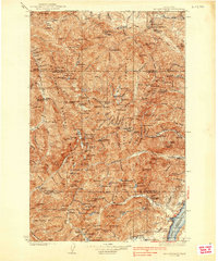
1938 Map of Mt Constance
USGS Topo · Published 1938About this map
Olympic National Forest and the recently established Olympic National Park define this 1930s high-elevation landscape. The topography, surveyed by G.S. Druhot and L.B. Lint, reveals a network of back-country infrastructure essential for forest management and early recreation. Numerous remote outposts like the Slab Creek Guard Sta and Elkhorn Guard Sta are connected by trails through the river valleys of the Dungeness River and Dosewallips River.
Find a feature on this map
98 named features on this map. Tap any name to fly to it.
Don’t see what you’re looking for? This feature index may not catch every label — zoom into the map to look around manually.
Map Details
Editions of this 1938 Mt Constance Map
4 editions found
Other maps of this area

1918 · Port Angeles
USGS Topo · 1:62,500

1919 · Port Crescent
USGS Topo · 1:62,500

1921 · Satsop
USGS Topo · 1:62,500

1935 · Mount Olympus
USGS Topo · 1:62,500

1936 · Point Misery
USGS Topo · 1:62,500

1938 · Mt Constance
USGS Topo · 1:125,000

1938 · Dungeness
USGS Topo · 1:62,500

1938 · Allyn
USGS Topo · 1:62,500

1939 · Port Townsend
USGS Topo · 1:62,500

1939 · Dungeness
USGS Topo · 1:62,500