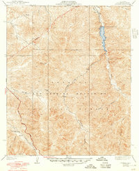
1940 Map of Mt. Emma
USGS Topo · Published 1948About this map
The San Gabriel Mountains dominate this 1940s landscape, a rugged terrain shaped by the water management needs of the growing high desert. The north-flowing Little Rock Creek is captured by the Little Rock Palmdale Dam, which diverts water into the Palmdale-Little Rock Ditch along the northern slopes. This infrastructure highlights the era's critical engineering required to sustain settlements just beyond the mountains' edge.
Find a feature on this map
25 named features on this map. Tap any name to fly to it.
Don’t see what you’re looking for? This feature index may not catch every label — zoom into the map to look around manually.
Map Details
Editions of this 1940 Mt. Emma Map
3 editions found
Other maps of this area

1900 · Tujunga
USGS Topo · 1:62,500

1901 · Southern California Sheet No. 1
USGS Topo · 1:250,000

1903 · Rock Creek
USGS Topo · 1:62,500

1904 · Southern California Sheet No. 1
USGS Topo · 1:250,000

1915 · Elizabeth Lake
USGS Topo · 1:125,000

1917 · Elizabeth Lake
USGS Topo · 1:125,000

1930 · Little Rock
USGS Topo · 1:24,000

1930 · Pearland
USGS Topo · 1:24,000

1932 · Palmdale
USGS Topo · 1:24,000

1934 · Pearland
USGS Topo · 1:24,000