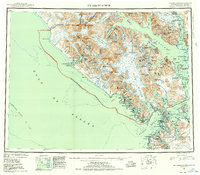
1951 Map of Mt Fairweather
USGS Topo · Published 1955About this map
Mt Fairweather stands as the towering focal point of this 1950s reconnaissance, marking the international border between Alaska and British Columbia. The landscape is dominated by the massive ice fields of the Fairweather Range and the intricate fjords of the Glacier Bay National Monument. To the south, the map details the maritime navigation routes through Cross Sound and Icy Strait, where small settlements like Elfin Cove and Port Althorp provided essential harbors for the local fishing fleet.
Find a feature on this map
137 named features on this map. Tap any name to fly to it.
Don’t see what you’re looking for? This feature index may not catch every label — zoom into the map to look around manually.
Map Details
Editions of this 1951 Mt Fairweather Map
2 editions found

Other maps of this area

1948 · Juneau B-6
USGS Topo · 1:63,360

1948 · Juneau C-6
USGS Topo · 1:63,360

1948 · Mount Fairweather A-2
USGS Topo · 1:63,360

1948 · Mount Fairweather B-1
USGS Topo · 1:63,360

1948 · Sitka D-6
USGS Topo · 1:63,360

1948 · Mount Fairweather B-2
USGS Topo · 1:63,360

1948 · Sitka D-8
USGS Topo · 1:63,360

1948 · Mount Fairweather D-1
USGS Topo · 1:63,360

1948 · Mount Fairweather D-2
USGS Topo · 1:63,360

1948 · Mount Fairweather A-1
USGS Topo · 1:63,360