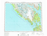
1961 Map of Mt Fairweather
USGS Topo · Published 1979About this map
Mt. Fairweather towers over the coast of Southeast Alaska, marking a prominent point on the international boundary between the United States and Canada. This map documents the frozen expanses of the Fairweather Range and the massive ice fields of Glacier Bay National Monument during the mid-twentieth century. The landscape is defined by its dramatic glacial systems, including the Grand Plateau Glacier spilling toward the Gulf of Alaska and the Margerie Glacier at the head of Tarr Inlet. Marine features dominate the southern half of the sheet, from the protected waters of Lituya Bay to the intricate passages of Cross Sound and Icy Strait. The northern reaches of Chichagof Island appear at the bottom edge, showing the proximity of the Inian Islands and Port Althorp to the towering peaks of the mainland.
Find a feature on this map
98 named features on this map. Tap any name to fly to it.
Don’t see what you’re looking for? This feature index may not catch every label — zoom into the map to look around manually.
Map Details
Editions of this 1961 Mt Fairweather Map
4 editions found

Other maps of this area

1948 · Juneau B-6
USGS Topo · 1:63,360

1948 · Juneau C-6
USGS Topo · 1:63,360

1948 · Mount Fairweather A-2
USGS Topo · 1:63,360

1948 · Mount Fairweather B-1
USGS Topo · 1:63,360

1948 · Sitka D-6
USGS Topo · 1:63,360

1948 · Mount Fairweather B-2
USGS Topo · 1:63,360

1948 · Sitka D-8
USGS Topo · 1:63,360

1948 · Mount Fairweather D-1
USGS Topo · 1:63,360

1948 · Mount Fairweather D-2
USGS Topo · 1:63,360

1948 · Mount Fairweather A-1
USGS Topo · 1:63,360