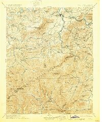
1912 Map of Mt Guyot
USGS Topo · Published 1929About this map
Newport serves as a primary hub where the French Broad River meets the northern slopes of the Great Smoky Mountains in this early twentieth-century survey. The landscape is defined by the sharp transition from the river valleys to high peaks such as Clingmans Dome and Mt Guyot. A network of small, isolated coves like Richardson Cove, Emerts Cove, and Jones Cove reveals a pattern of mountain settlement long before the formalization of modern park boundaries. To the south, the Qualla Indian Reservation and Pisgah National Forest mark early federal land management. Along the river corridors, the Southern River railroad line connects riverside communities like Bridgeport, Delrio, and Naillon Sta, highlighting the era's reliance on rail for commerce through the mountain gaps.
Find a feature on this map
153 named features on this map. Tap any name to fly to it.
Don’t see what you’re looking for? This feature index may not catch every label — zoom into the map to look around manually.
Map Details
Editions of this 1912 Mt Guyot Map
5 editions found

Other maps of this area

1883 · Morristown
USGS Topo · 1:125,000

1886 · Knoxville
USGS Topo · 1:125,000

1891 · Cowee
USGS Topo · 1:125,000

1892 · Greeneville
USGS Topo · 1:125,000

1892 · Knoxville
USGS Topo · 1:125,000

1893 · Mt Guyot
USGS Topo · 1:125,000

1893 · Morristown
USGS Topo · 1:125,000

1894 · Asheville
USGS Topo · 1:125,000

1894 · Knoxville
USGS Topo · 1:125,000

1895 · Morristown
USGS Topo · 1:125,000