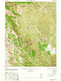
1963 Map of Mt. Hamilton
USGS Topo · Published 1963About this map
Mt Hamilton serves as the focal point of this 1940s-era terrain study, dominated by the notable Lick Observatory and its surrounding peaks. The landscape is a network of ridges and canyons, where Packard Ridge and Valpe Ridge divide complex drainage systems like Arroyo Hondo and Isabel Creek. The settlement pattern is defined by isolated family holdings and ranches, such as Patton Ranch and Fisher Homestead, suggesting a specialized livestock or mountain agriculture economy during the mid-century. Institutional presence is visible through the Smith Creek Ranger Sta and the Halls Valley Sch, which served the scattered residents of Halls Valley. A prominent Jeep Trail traverses the Burnt Hills, providing a look at the early motorized access routes into the high country of the Alameda and Santa Clara borderlands.
Find a feature on this map
70 named features on this map. Tap any name to fly to it.
Don’t see what you’re looking for? This feature index may not catch every label — zoom into the map to look around manually.
Map Details
Editions of this 1963 Mt. Hamilton Map
This is the sole edition of this map. No revisions or reprints were ever made.
Other maps of this area

1889 · San Jose
USGS Topo · 1:62,500

1897 · San Jose
USGS Topo · 1:62,500

1897 · Mt. Hamilton
USGS Topo · 1:62,500

1899 · San Jose
USGS Topo · 1:62,500

1906 · Pleasanton
USGS Topo · 1:62,500

1907 · Tesla
USGS Topo · 1:62,500

1916 · New Almaden
USGS Topo · 1:48,000

1917 · Morgan Hill
USGS Topo · 1:62,500

1919 · New Almaden
USGS Topo · 1:62,500

1921 · Gilroy Hot Springs
USGS Topo · 1:62,500