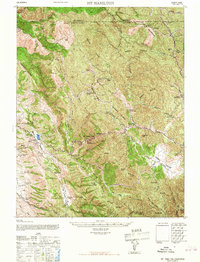
1967 Map of Mt. Hamilton
USGS Topo · Published 1967About this map
Lick Observatory crowns the summit of Mt Hamilton, serving as a prominent landmark in this rugged portion of the Diablo Range. The landscape is defined by a dense network of ridges and canyons, including Valpe Ridge and Castle Ridge, which frame the high-elevation basins of Halls Valley and Isabel Valley. This mid-century survey captures a transition point in Santa Clara County history, where the upland interior remained dominated by established family holdings such as the Grant Ranch, Hendricks Ranch, and the Fisher Homestead.
Find a feature on this map
64 named features on this map. Tap any name to fly to it.
Don’t see what you’re looking for? This feature index may not catch every label — zoom into the map to look around manually.
Map Details
Editions of this 1967 Mt. Hamilton Map
This is the sole edition of this map. No revisions or reprints were ever made.
Other maps of this area

1889 · San Jose
USGS Topo · 1:62,500

1897 · San Jose
USGS Topo · 1:62,500

1897 · Mt. Hamilton
USGS Topo · 1:62,500

1899 · San Jose
USGS Topo · 1:62,500

1906 · Pleasanton
USGS Topo · 1:62,500

1907 · Tesla
USGS Topo · 1:62,500

1916 · New Almaden
USGS Topo · 1:48,000

1917 · Morgan Hill
USGS Topo · 1:62,500

1919 · New Almaden
USGS Topo · 1:62,500

1921 · Gilroy Hot Springs
USGS Topo · 1:62,500