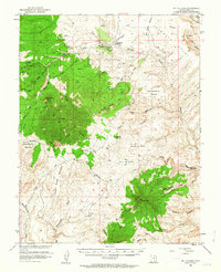
1952 Map of Mt Hillers
USGS Topo · Published 1963About this map
Mt Hillers dominates the northern reaches of this landscape, rising above a network of drainages and ridges that define the Henry Mountains region. Mapping by the Geological Survey in the early 1950s, in cooperation with the Atomic Energy Commission, highlights the isolation and specific utility of the terrain. The area shows evidence of mineral exploration and ranching, from the Prospect and Farmers Knob sites to the established Trachyte Ranch near Trachyte Creek. A remote Landing Strip and various Tunnels suggest the logistical challenges of surveying and industrial activity in this part of Garfield County. To the south, Mt Holmes and Mt Ellsworth anchor the high ground, separated by the Star Creek Benches and the prominent Maidenwater Sands. Family names and local descriptors appear throughout, identifying landmarks like Juds Knoll, Johns Knoll, and Freds Ridge alongside practical markers such as the Woodruff Spr Water Tank.
Find a feature on this map
70 named features on this map. Tap any name to fly to it.
Don’t see what you’re looking for? This feature index may not catch every label — zoom into the map to look around manually.
Map Details
Editions of this 1952 Mt Hillers Map
4 editions found
Other maps of this area

1885 · San Rafael
USGS Topo · 1:250,000

1886 · Henry Mountains
USGS Topo · 1:250,000

1892 · Henry Mountains
USGS Topo · 1:250,000

1952 · Mt Pennell 1 SW
USGS Topo · 1:24,000

1952 · Orange Cliffs 3 SW
USGS Topo · 1:24,000

1952 · Mount Ellen 4 SW
USGS Topo · 1:24,000

1952 · Mt Pennell 2 NE
USGS Topo · 1:24,000

1952 · Mancos Mesa
USGS Topo · 1:62,500

1952 · Mt Pennell 1 NE
USGS Topo · 1:24,000

1952 · Mt Hillers
USGS Topo · 1:62,500