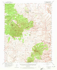
1952 Map of Mt Hillers
USGS Topo · Published 1972About this map
Henry Mountains dominate this 1952 topographic study, showing the high-elevation peaks of Mt Hillers, Mt Holmes, and Mt Ellsworth rising above the surrounding desert floor. The landscape is marked by the infrastructure of early ranching and mining, notably the Trachyte Ranch in the north and the Del Monte Mine to the south. Mapped in cooperation with the Atomic Energy Commission during a period of intense geological exploration in Utah, the survey identifies critical water sources in an arid environment, including the Woodruff Spr Water Tank and various named seeps like Maidenwater Spring and Hog Spring. The eastern edge is defined by deep incisions like Trachyte Creek and the notable Hoskininni Monument. This document preserves the complex system of local place names for high-desert features such as The Cove, Black Hole, and Juds Knoll, providing a clear view of the territory before modern recreational development.
Find a feature on this map
107 named features on this map. Tap any name to fly to it.
Don’t see what you’re looking for? This feature index may not catch every label — zoom into the map to look around manually.
Map Details
Editions of this 1952 Mt Hillers Map
4 editions found
Other maps of this area

1885 · San Rafael
USGS Topo · 1:250,000

1886 · Henry Mountains
USGS Topo · 1:250,000

1892 · Henry Mountains
USGS Topo · 1:250,000

1952 · Mt Pennell 1 SW
USGS Topo · 1:24,000

1952 · Orange Cliffs 3 SW
USGS Topo · 1:24,000

1952 · Mount Ellen 4 SW
USGS Topo · 1:24,000

1952 · Mt Pennell 2 NE
USGS Topo · 1:24,000

1952 · Mancos Mesa
USGS Topo · 1:62,500

1952 · Mt Pennell 1 NE
USGS Topo · 1:24,000

1952 · Mt Hillers
USGS Topo · 1:62,500