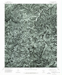
1974 Map of Mt Judea NE
USGS Topo · Published 1975About this map
The Buffalo River snakes across the northern reaches of this Newton County landscape, carving through the dense timber and deep hollows characteristic of the Arkansas Ozarks. This orthophotograph, derived from 1974 aerial imagery, provides a literal overhead perspective of the rural topography as it existed in the mid-1970s. The settlement of Mt Judea serves as the primary community hub, situated atop the ridges above the winding paths of Big Creek and Cave Creek. The map reveals a mosaic of small clearings and homesteads that follow the narrow valley floors and gentler ridge tops, illustrating the persistent influence of drainage patterns on settlement in this rugged interior region. Unlike traditional line-drawn maps, the photographic base preserves every farm field and forest edge exactly as it appeared during the spring flyover.
Find a feature on this map
4 named features on this map. Tap any name to fly to it.
Don’t see what you’re looking for? This feature index may not catch every label — zoom into the map to look around manually.
Map Details
Editions of this 1974 Mt Judea NE Map
This is the sole edition of this map. No revisions or reprints were ever made.
Other maps of this area

1892 · Marshall
USGS Topo · 1:125,000

1893 · Yellville
USGS Topo · 1:125,000

1894 · Marshall
USGS Topo · 1:125,000

1901 · Marshall
USGS Topo · 1:125,000

1903 · Yellville
USGS Topo · 1:125,000

1904 · Harrison
USGS Topo · 1:125,000

1905 · Harrison
USGS Topo · 1:125,000

1905 · Yellville
USGS Topo · 1:125,000

1929 · Yellville
USGS Topo · 1:125,000

1933 · Mt Judea
USGS Topo · 1:62,500