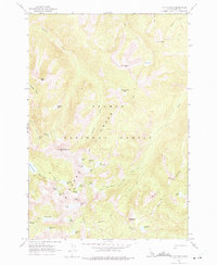
1962 Map of Mt Mc Guire
USGS Topo · Published 1975About this map
Bighorn Crags dominate this high-elevation landscape within the Salmon National Forest, as documented in 1962. The area is defined by sharp granite ridges and a dense concentration of glacial cirque lakes, including the large Ship Island Lake and Big Clear Lake. Many of the smaller bodies of water carry descriptive names like Gooseneck Lake, Airplane Lake, and Barking Fox Lake, illustrating how late 20th-century surveyors and wilderness travelers identified specific pockets of this alpine terrain. Rising above these basins are several prominent peaks and ridges, such as Mt McGuire, the high Fishfin Ridge, and Dome Mtn. The map traces a network of unnamed trails, indicating the era's primary access routes through the Salmon River Mountains before more modern infrastructure. Waterways like Roaring Creek and Goat Creek drain these steep slopes, eventually feeding the larger river systems of Lemhi County.
Find a feature on this map
44 named features on this map. Tap any name to fly to it.
Don’t see what you’re looking for? This feature index may not catch every label — zoom into the map to look around manually.
Map Details
Editions of this 1962 Mt Mc Guire Map
3 editions found
Other maps of this area

1950 · Blackbird Mtn
USGS Topo · 1:62,500

1951 · Blackbird Mtn
USGS Topo · 1:62,500

1956 · Elk City
USGS Topo · 1:250,000

1960 · Elk City
USGS Topo · 1:250,000

1960 · Shoup
USGS Topo · 1:62,500

1962 · Hoodoo Meadows
USGS Topo · 1:24,000

1962 · Long Tom Mtn
USGS Topo · 1:24,000

1962 · Puddin Mtn
USGS Topo · 1:24,000

1962 · Aggipah Mtn
USGS Topo · 1:24,000

1962 · Mt Mc Guire
USGS Topo · 1:24,000