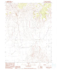
1990 Map of Mt. Moses SE
USGS Topo · Published 1990About this map
Fish Creek Mountains dominate the northern terrain of this Central Nevada landscape, where the high desert peaks give way to the broad alluvial plains of Antelope Valley. The mapping, based on 1950s aerial photography and updated through the late 1980s, reveals a sparse but functional ranching environment. The Cottonwood Ranch serves as a primary point of human activity, situated near the seasonal drainage of Cottonwood Creek. To the east, the Reese River Valley and Cain Creek provide the geographic structure for this arid region. The presence of numerous labeled wells and a Waste Dump indicates the intersection of resource management and local utility in a remote Lander County setting. The transition from the rugged Cottonwood Basin to the valley floors illustrates the classic Great Basin topography of the late twentieth century.
Find a feature on this map
10 named features on this map. Tap any name to fly to it.
Don’t see what you’re looking for? This feature index may not catch every label — zoom into the map to look around manually.
Map Details
Editions of this 1990 Mt. Moses SE Map
This is the sole edition of this map. No revisions or reprints were ever made.
Other maps of this area

1932 · Sonoma Range
USGS Topo · 1:250,000

1939 · Sonoma Range
USGS Topo · 1:250,000

1955 · Millett
USGS Topo · 1:250,000

1955 · Winnemucca
USGS Topo · 1:250,000

1958 · Winnemucca
USGS Topo · 1:250,000

1959 · Millett
USGS Topo · 1:250,000

1961 · The Cedars
USGS Topo · 1:62,500

1961 · Mt. Moses
USGS Topo · 1:62,500

1962 · Winnemucca
USGS Topo · 1:250,000
1969 · Manhattan Mtn NW
USGS Topo · 1:24,000