
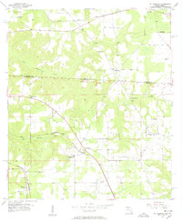
1955 Map of Mt Pleasant
USGS Topo · Published 1957About this map
The Georgia-Florida border country comes into sharp focus during the mid-1950s, defined by the winding paths of North Mosquito Creek and South Mosquito Creek. This agricultural and timber landscape is anchored by the settlement of Mt Pleasant, where the Seaboard Air Line railroad intersects the local road network. The map reveals a deeply rooted community infrastructure, with small rural centers like Faceville and Hardaway supporting several neighborhood institutions, including the Faceville Sch and Mt Pleasant Sch.
Find a feature on this map
24 named features on this map. Tap any name to fly to it.
Don’t see what you’re looking for? This feature index may not catch every label — zoom into the map to look around manually.
Map Details
Editions of this 1955 Mt Pleasant Map
2 editions found
Other maps of this area

1954 · Tallahassee
USGS Topo · 1:250,000

1955 · Reynoldsville
USGS Topo · 1:24,000

1955 · Sycamore
USGS Topo · 1:24,000

1955 · Chattahoochee
USGS Topo · 1:24,000

1955 · Bainbridge
USGS Topo · 1:62,500

1956 · Dogtown
USGS Topo · 1:24,000

1959 · Tallahassee
USGS Topo · 1:250,000

1959 · Gretna
USGS Topo · 1:24,000

1959 · Quincy
USGS Topo · 1:24,000

1960 · Tallahassee
USGS Topo · 1:250,000