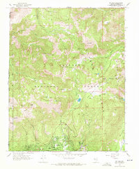
1968 Map of Mt. Rose
USGS Topo · Published 1971About this map
Incline Village sits at the northern edge of the Lake Tahoe basin in the late 1960s, showing a community defined by its recreation and steep geography. Residential streets like Northwood Blvd and Southwood Blvd circle the town center, while a local Trailer Park and Incline High Sch anchor the burgeoning settlement. The surrounding Toiyabe National Forest is heavily marked with the infrastructure of mid-century alpine tourism, including a Tramway, a Ski Lift, and the Mt Rose Campground near the Mt Rose Summit. High-altitude water bodies such as Incline Lake and Tamarack Lake drain toward the basin through steep canyons like Third Creek, while on the eastern slopes, Little Valley remains relatively undeveloped compared to the growing village. Old Pack Trails and scattered Prospects hint at earlier mountain exploration before the era of modern ski resorts.
Find a feature on this map
48 named features on this map. Tap any name to fly to it.
Don’t see what you’re looking for? This feature index may not catch every label — zoom into the map to look around manually.
Map Details
Editions of this 1968 Mt. Rose Map
2 editions found
Other maps of this area

1891 · Carson
USGS Topo · 1:125,000

1891 · Truckee
USGS Topo · 1:125,000

1893 · Carson
USGS Topo · 1:125,000

1893 · Truckee
USGS Topo · 1:125,000

1895 · Truckee
USGS Topo · 1:125,000

1932 · Truckee
USGS Topo · 1:96,000

1940 · Truckee
USGS Topo · 1:125,000

1950 · Mt. Rose
USGS Topo · 1:62,500

1952 · Mt. Rose
USGS Topo · 1:62,500
1955 · Kings Beach
USGS Topo · 1:24,000