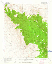
1957 Map of Mt. Stirling
USGS Topo · Published 1962About this map
Stirling Mine and a nearby shaft mark the eastern slopes of the Spring Mountains in this mid-century survey of the high desert. The landscape is defined by the contrast between the sharp elevation of Mt Stirling and the broad, arid expanse of the Pahrump Valley to the southwest. Water sources are the primary indicators of human activity and survival in this environment, with several named locations such as Wheeler Well, Bill Smith Springs, and Horseshutem Springs dotting the terrain.
Find a feature on this map
26 named features on this map. Tap any name to fly to it.
Don’t see what you’re looking for? This feature index may not catch every label — zoom into the map to look around manually.
Map Details
Editions of this 1957 Mt. Stirling Map
2 editions found

Other maps of this area

1907 · Las Vegas
USGS Topo · 1:250,000

1908 · Furnace Creek
USGS Topo · 1:250,000

1908 · Las Vegas
USGS Topo · 1:250,000

1910 · Furnace Creek
USGS Topo · 1:250,000

1942 · Indian Spring
USGS Topo · 1:125,000

1942 · Skull Mountain
USGS Topo · 1:125,000

1948 · Death Valley
USGS Topo · 1:250,000

1952 · Specter Range
USGS Topo · 1:62,500

1952 · Mercury
USGS Topo · 1:62,500

1954 · Las Vegas
USGS Topo · 1:250,000