
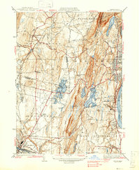
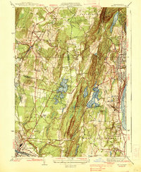
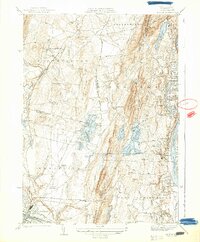
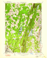
1938 Map of Mt Tom
USGS Topo · Published 1948About this map
Mt Tom State Reservation and the Mt Tom Range anchor this topographic study, where the steep ridgeline separates the industrial corridor of the Connecticut River from the interior upland basins. In the late 1930s and 1940s, the landscape around Holyoke and Westfield shows a complex mix of early aviation infrastructure, like Barnes Municipal Airport and multiple Airway Beacons, alongside long-established social institutions such as the Orphans Home and St Jerome Cem. The water management network is particularly dense here, featuring the Ashley Pond and Pequot Pond reservoirs, and specialized facilities like the Paderewski Pumping Sta. Transportation is defined by the New York New Haven and Hartford RR and the Boston and Albany RR, which served the industrial heart of the Pioneer Valley.
Find a feature on this map
93 named features on this map. Tap any name to fly to it.
Don’t see what you’re looking for? This feature index may not catch every label — zoom into the map to look around manually.
Map Details
Editions of this 1938 Mt Tom Map
6 editions found

Other maps of this area

1885 · Northampton
USGS Topo · 1:62,500

1886 · Springfield
USGS Topo · 1:62,500

1886 · Chesterfield
USGS Topo · 1:62,500

1886 · Northampton
USGS Topo · 1:62,500

1887 · Granville
USGS Topo · 1:62,500

1888 · Chesterfield
USGS Topo · 1:62,500

1889 · Springfield
USGS Topo · 1:62,500

1889 · Granville
USGS Topo · 1:62,500

1891 · Northampton
USGS Topo · 1:62,500

1893 · Northampton
USGS Topo · 1:62,500