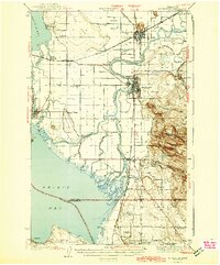
1943 Map of Mt Vernon
USGS Topo · Published 1943About this map
The Skagit River dominates this mid-century landscape as it splits into the North Fork and South Fork, creating a complex delta of sloughs and islands before reaching Skagit Bay. To the east, the urban center of Mt Vernon serves as a regional hub, connected to Burlington and Sedro-Woolley by the Great Northern and Northern Pacific railroads. The map reveals a deeply established agricultural and maritime network, where small communities like La Conner sit along the Swinomish Slough and rural life is anchored by local institutions such as Pleasant Ridge Sch and Milltown Ch. Higher ground is found at Devils Mtn and Bay View Ridge, providing a stark contrast to the low-lying marshlands of Olympia Marsh. This survey details the intricate drainage system of the Skagit flats, including Indian Slough and Freshwater Slough, which were vital to the area's development and transport during the 1940s.
Find a feature on this map
60 named features on this map. Tap any name to fly to it.
Don’t see what you’re looking for? This feature index may not catch every label — zoom into the map to look around manually.
Map Details
Editions of this 1943 Mt Vernon Map
2 editions found
Other maps of this area

1911 · Mount Vernon
USGS Topo · 1:125,000

1918 · Samish Lake
USGS Topo · 1:62,500

1921 · Wickersham
USGS Topo · 1:62,500

1939 · Coupeville
USGS Topo · 1:62,500

1940 · Mt Vernon
USGS Topo · 1:62,500

1941 · Marysville
USGS Topo · 1:62,500

1943 · Marysville
USGS Topo · 1:62,500

1943 · Mt Vernon
USGS Topo · 1:62,500

1943 · Stanwood
USGS Topo · 1:62,500

1943 · Deception Pass
USGS Topo · 1:62,500