
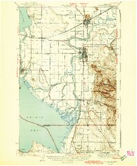
1943 Map of Mt Vernon
USGS Topo · Published 1943About this map
The Skagit River dominates this mid-century landscape as it winds toward its delta, branching into the North Fork and South Fork before reaching Skagit Bay. The region's complex water network is fully articulated, showing numerous drainage features like Indian Slough, Sullivan Slough, and Tom Moore Slough. This detailed mapping reveals a transition between the established riverfront settlements and the rising upland of Devils Mtn, while the agricultural importance of the flatlands is evident in the numerous rural schoolhouses such as Harmony Sch and Riverside Sch.
Find a feature on this map
62 named features on this map. Tap any name to fly to it.
Don’t see what you’re looking for? This feature index may not catch every label — zoom into the map to look around manually.
Map Details
Editions of this 1943 Mt Vernon Map
2 editions found
Other maps of this area

1911 · Mount Vernon
USGS Topo · 1:125,000

1918 · Samish Lake
USGS Topo · 1:62,500

1921 · Wickersham
USGS Topo · 1:62,500

1939 · Coupeville
USGS Topo · 1:62,500

1940 · Mt Vernon
USGS Topo · 1:62,500

1941 · Marysville
USGS Topo · 1:62,500

1943 · Marysville
USGS Topo · 1:62,500

1943 · Stanwood
USGS Topo · 1:62,500

1943 · Deception Pass
USGS Topo · 1:62,500

1943 · Anacortes
USGS Topo · 1:62,500