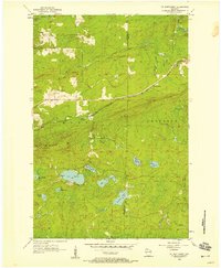
1956 Map of Mt. Whittlesey
USGS Topo · Published 1958About this map
Mt Whittlesey dominates the topography of this mid-1950s survey of north-central Wisconsin, a landscape defined by industrial history and glaciated terrain. The remnants of local iron mining are visible at the Berkshire Mine Ruins, while the Soo Line railroad (marked as the Minneapolis St Paul and Sault Ste Marie) cuts through the center of the sheet, serving the small settlement at Ballou. The area is characterized by a dense network of water bodies, including Lake Galilee, Caroline Lake, and Eureka Lake, alongside the winding course of the Bad River and the Tyler Forks. The presence of a Lookout Tower on the heights reflects the region's managed forest environment. The division between Morse and Anderson townships, along with the boundary between Ashland and Iron counties, provides a clear framework for researchers tracing 20th-century property and administrative lines in the Wisconsin Northwoods.
Find a feature on this map
28 named features on this map. Tap any name to fly to it.
Don’t see what you’re looking for? This feature index may not catch every label — zoom into the map to look around manually.
Map Details
Editions of this 1956 Mt. Whittlesey Map
This is the sole edition of this map. No revisions or reprints were ever made.
Other maps of this area

1940 · Butternut
USGS Topo · 1:48,000

1940 · Upson
USGS Topo · 1:48,000

1942 · Glidden
USGS Topo · 1:48,000

1942 · Mellen
USGS Topo · 1:48,000

1943 · Upson
USGS Topo · 1:48,000

1945 · Glidden
USGS Topo · 1:48,000

1945 · Mellen
USGS Topo · 1:48,000

1947 · Butternut
USGS Topo · 1:48,000

1950 · Butternut
USGS Topo · 1:48,000

1953 · Ashland
USGS Topo · 1:250,000