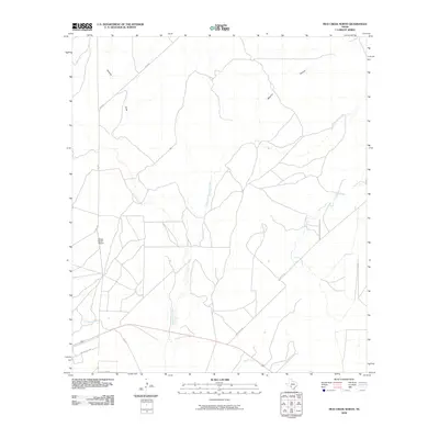
2010 Map of Mud Creek North
USGS Topo · Published 2010About this map
Bertani Ranch Airport stands as a focal point in this sparsely settled region of Val Verde County, characterized by a network of ephemeral watercourses and ranch access roads. The landscape is defined by the drainage systems of Sacatosa Creek, Sycamore Creek, and the East Fork Sycamore Creek, which carve through the terrain alongside Maurice Canyon and Javelina Draw. Local connectivity is provided by FM 2523 and Mud Creek Rd, serving rural interests like Rancho Del Rio. The layout of these ranch roads and named crossings reflects the enduring pastoral economy and the geographical reliance on intermittent creek beds for boundary and transit markers in the Texas brush country.
Find a feature on this map
12 named features on this map. Tap any name to fly to it.
Don’t see what you’re looking for? This feature index may not catch every label — zoom into the map to look around manually.
Map Details
Editions of this 2010 Mud Creek North Map
This is the sole edition of this map. No revisions or reprints were ever made.
Other maps of this area

1941 · Standart
USGS Topo · 1:62,500

1943 · Standart
USGS Topo · 1:62,500

1943 · Del Rio
USGS Topo · 1:62,500

1944 · Flat Rock
USGS Topo · 1:62,500

1944 · Devils Lake
USGS Topo · 1:62,500

1958 · Del Rio
USGS Topo · 1:250,000

1964 · Del Rio
USGS Topo · 1:250,000

1972 · Rough Canyon SE
USGS Topo · 1:24,000

1972 · Del Rio SE
USGS Topo · 1:24,000
1972 · Del Rio NE
USGS Topo · 1:24,000