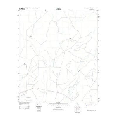
2012 Map of Mud Creek North
USGS Topo · Published 2012About this map
Bertani Ranch Airport sits as a primary landmark in this expanse of Val Verde County, where the desert landscape is defined by its seasonal drainage network. The map illustrates a complex system of arid waterways, including the main channel of Sycamore Cr and its significant tributary, the E Fork Sycamore Cr. These ephemeral features, along with Javelina Draw and Maurice Canyon, dictate the movement of ranch roads and local trails through the scrubland. To the east, the eponymous Mud Cr winds through the terrain, flanked by Mud Creek Rd and Rio Springs Rd. The presence of established ranch names like Rancho Del Rio and localized road markers such as Buck Trl and Fox Trl highlights the area's ongoing agricultural and ranching legacy in Southwest Texas.
Find a feature on this map
14 named features on this map. Tap any name to fly to it.
Don’t see what you’re looking for? This feature index may not catch every label — zoom into the map to look around manually.
Map Details
Editions of this 2012 Mud Creek North Map
This is the sole edition of this map. No revisions or reprints were ever made.
Other maps of this area

1941 · Standart
USGS Topo · 1:62,500

1943 · Standart
USGS Topo · 1:62,500

1943 · Del Rio
USGS Topo · 1:62,500

1944 · Flat Rock
USGS Topo · 1:62,500

1944 · Devils Lake
USGS Topo · 1:62,500

1958 · Del Rio
USGS Topo · 1:250,000

1964 · Del Rio
USGS Topo · 1:250,000

1972 · Rough Canyon SE
USGS Topo · 1:24,000

1972 · Del Rio SE
USGS Topo · 1:24,000
1972 · Del Rio NE
USGS Topo · 1:24,000