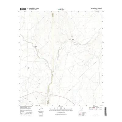
2016 Map of Mud Creek North
USGS Topo · Published 2016About this map
East Fork Sycamore Creek and its many tributaries, including Sycamore Creek and Sacatosa Cr, define the drainage patterns across this arid South Texas landscape. The terrain is marked by significant topographical shifts, particularly around Maurice Canyon and the Javelina Draw, which cut through the scrubland. This 2016 survey illustrates a largely rural expanse along the border of Val Verde and Kinney counties, where large-scale ranching and aviation intersect at the Bertani Ranch Airport. Transportation is dictated by the route of FM 2523 and a network of private or secondary roads like Mud Creek Rd and Rancho Del Rio. The map provides a detailed view of the modern land divisions and water features that continue to shape local agriculture and ranching operations in this corner of the state.
Find a feature on this map
17 named features on this map. Tap any name to fly to it.
Don’t see what you’re looking for? This feature index may not catch every label — zoom into the map to look around manually.
Map Details
Editions of this 2016 Mud Creek North Map
This is the sole edition of this map. No revisions or reprints were ever made.
Other maps of this area

1941 · Standart
USGS Topo · 1:62,500

1943 · Standart
USGS Topo · 1:62,500

1943 · Del Rio
USGS Topo · 1:62,500

1944 · Flat Rock
USGS Topo · 1:62,500

1944 · Devils Lake
USGS Topo · 1:62,500

1958 · Del Rio
USGS Topo · 1:250,000

1964 · Del Rio
USGS Topo · 1:250,000

1972 · Rough Canyon SE
USGS Topo · 1:24,000

1972 · Del Rio SE
USGS Topo · 1:24,000
1972 · Del Rio NE
USGS Topo · 1:24,000