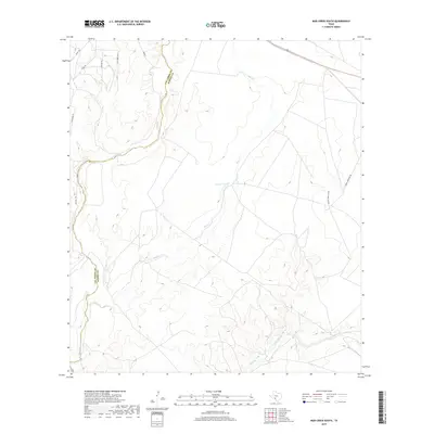
2019 Map of Mud Creek South
USGS Topo · Published 2019About this map
The county boundary between Val Verde Co and Kinney Co bisects this West Texas landscape, where the seasonal drainage systems of Pinto Creek and Sycamore Cr carve through the arid terrain. The map reveals a transition from the winding course of Mud Cr in the north to the more complex branching of Pinto Cr in the southeast. While largely undeveloped, the area is defined by a network of ranch and access roads, including Jack Hill Rd and Hadley Ward Law Rd, which provide passage through the upland areas. Small-scale water management is evident at Mud Cr Tank, reflecting the essential infrastructure for cattle ranching in this portion of the Edwards Plateau. The presence of local pathways like Javalina Trl and Fury Creek Trl suggests a modern rural residential or recreational layer atop the traditional ranching heritage.
Find a feature on this map
14 named features on this map. Tap any name to fly to it.
Don’t see what you’re looking for? This feature index may not catch every label — zoom into the map to look around manually.
Map Details
Editions of this 2019 Mud Creek South Map
This is the sole edition of this map. No revisions or reprints were ever made.
Other maps of this area

1941 · Standart
USGS Topo · 1:62,500

1941 · Tequesquite Creek
USGS Topo · 1:62,500

1943 · Standart
USGS Topo · 1:62,500

1943 · Del Rio
USGS Topo · 1:62,500

1944 · Sycamore Ranch
USGS Topo · 1:62,500

1944 · Tequesquite Creek
USGS Topo · 1:62,500

1958 · Del Rio
USGS Topo · 1:250,000

1964 · Del Rio
USGS Topo · 1:250,000

1972 · Del Rio SE
USGS Topo · 1:24,000
1972 · Del Rio NE
USGS Topo · 1:24,000