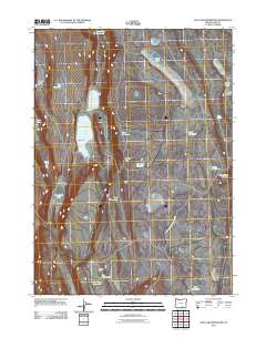
2011 Map of Mud Lake Reservoir
USGS Topo · Published 2011About this map
The high desert of Lake County, Oregon, is defined by its complex network of water management features and seasonal basins. This 2011 survey illustrates the reliance on localized water storage in an arid landscape, where structures like Mud Lake Reservoir, Jack Reservoir, and the series of small reservoirs including Tee Reservoir and Slice Reservoir dictate the movement across the terrain. The landscape is punctuated by broad, open areas such as Fairy Flat and significant elevations like Little Juniper Mountain.
Find a feature on this map
26 named features on this map. Tap any name to fly to it.
Don’t see what you’re looking for? This feature index may not catch every label — zoom into the map to look around manually.
Map Details
Editions of this 2011 Mud Lake Reservoir Map
This is the sole edition of this map. No revisions or reprints were ever made.
Other maps of this area

1955 · Adel
USGS Topo · 1:250,000

1957 · Adel
USGS Topo · 1:250,000

1958 · Adel
USGS Topo · 1:250,000

1962 · Adel
USGS Topo · 1:250,000

1967 · Jacobs Reservoir
USGS Topo · 1:24,000

1967 · Alger Lake
USGS Topo · 1:24,000

1967 · Crump Lake
USGS Topo · 1:24,000
1968 · Piute Reservoir
USGS Topo · 1:24,000

1968 · Guano Lake
USGS Topo · 1:24,000
1968 · Calderwood Reservoir
USGS Topo · 1:24,000