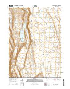
2014 Map of Mud Lake Reservoir
USGS Topo · Published 2014About this map
Mud Lake Reservoir and its surrounding high-desert catchment dominate this remote corner of Lake County, where water management is etched into the landscape via numerous basins and tanks. The terrain is characterized by a series of shallow lakes and man-made impoundments like Big-Hole Reservoir and Trial Reservoir, which support the region's ranching and livestock operations. Settlement is virtually non-existent, replaced by a network of utilitarian tracks such as Mud Lk and School Section roads that connect isolated landmarks. From the northern reach of Fisher Canyon down to the wide expanse of Greaser Basin, the map reveals a geography defined by seasonal water flow and drainage patterns. Notable elevations like Little Juniper Mtn provide relief above the flat, alkaline beds of Mud Lake and Famine Lake, illustrating the harsh but carefully utilized topography of the Oregon outback.
Find a feature on this map
41 named features on this map. Tap any name to fly to it.
Don’t see what you’re looking for? This feature index may not catch every label — zoom into the map to look around manually.
Map Details
Editions of this 2014 Mud Lake Reservoir Map
This is the sole edition of this map. No revisions or reprints were ever made.
Other maps of this area

1955 · Adel
USGS Topo · 1:250,000

1957 · Adel
USGS Topo · 1:250,000

1958 · Adel
USGS Topo · 1:250,000

1962 · Adel
USGS Topo · 1:250,000

1967 · Jacobs Reservoir
USGS Topo · 1:24,000

1967 · Alger Lake
USGS Topo · 1:24,000

1967 · Crump Lake
USGS Topo · 1:24,000
1968 · Piute Reservoir
USGS Topo · 1:24,000

1968 · Guano Lake
USGS Topo · 1:24,000
1968 · Calderwood Reservoir
USGS Topo · 1:24,000