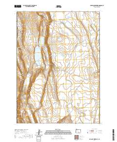
2020 Map of Mud Lake Reservoir
USGS Topo · Published 2020About this map
Mud Lake Reservoir and its surrounding high-desert basins define this Lake County landscape, where water management is the primary imprint on the terrain. The map reveals a complex network of catchment features such as Blow Mud Reservoir, Jack Reservoir, and Rick Reservoir, interspersed with natural depressions like Famine Lake and Moon Lake. These features reflect the vital importance of seasonal water storage in this arid region, supporting local ranching and land use across the wide expanses of Fairy Flat.
Find a feature on this map
35 named features on this map. Tap any name to fly to it.
Don’t see what you’re looking for? This feature index may not catch every label — zoom into the map to look around manually.
Map Details
Editions of this 2020 Mud Lake Reservoir Map
This is the sole edition of this map. No revisions or reprints were ever made.
Other maps of this area

1955 · Adel
USGS Topo · 1:250,000

1957 · Adel
USGS Topo · 1:250,000

1958 · Adel
USGS Topo · 1:250,000

1962 · Adel
USGS Topo · 1:250,000

1967 · Jacobs Reservoir
USGS Topo · 1:24,000

1967 · Alger Lake
USGS Topo · 1:24,000

1967 · Crump Lake
USGS Topo · 1:24,000
1968 · Piute Reservoir
USGS Topo · 1:24,000

1968 · Guano Lake
USGS Topo · 1:24,000
1968 · Calderwood Reservoir
USGS Topo · 1:24,000