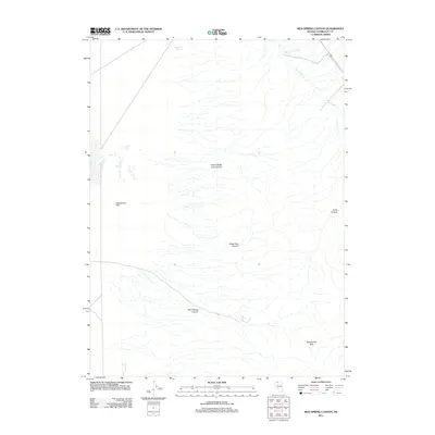
2011 Map of Mud Spring Canyon
USGS Topo · Published 2011About this map
Daveytown Flat sits on the western edge of this landscape, a high desert expanse defined by the intricate drainage systems of the Bloody Run Hills. The area is characterized by a series of significant erosional features including North Bucks Trail Canyon, Bucks Trail Canyon, and the primary drainage of Mud Spring Canyon. These canyons channel seasonal water from the uplands toward the flats, supporting isolated water sources such as Mud Spring and Sandbank Spring. Small perennial or intermittent flows like Porcupine Creek and Tony Creek cut through the northern territory, illustrating the rugged hydrology of this part of Humboldt County. The land remains largely undeveloped, preserving the original character of the trail systems and canyons that have historically guided movement through this arid basin and range environment.
Find a feature on this map
10 named features on this map. Tap any name to fly to it.
Don’t see what you’re looking for? This feature index may not catch every label — zoom into the map to look around manually.
Map Details
Editions of this 2011 Mud Spring Canyon Map
This is the sole edition of this map. No revisions or reprints were ever made.
Other maps of this area

1882 · Paradise
USGS Topo · 1:250,000

1893 · Paradise
USGS Topo · 1:250,000

1955 · McDermitt
USGS Topo · 1:250,000

1958 · Paradise Valley
USGS Topo · 1:62,500

1958 · Awakening Peak
USGS Topo · 1:62,500

1959 · McDermitt
USGS Topo · 1:250,000

1959 · Bliss
USGS Topo · 1:62,500
1982 · Andorno Ranch
USGS Topo · 1:24,000
1982 · Gallagher Flat
USGS Topo · 1:24,000
1982 · Silver State Draw
USGS Topo · 1:24,000