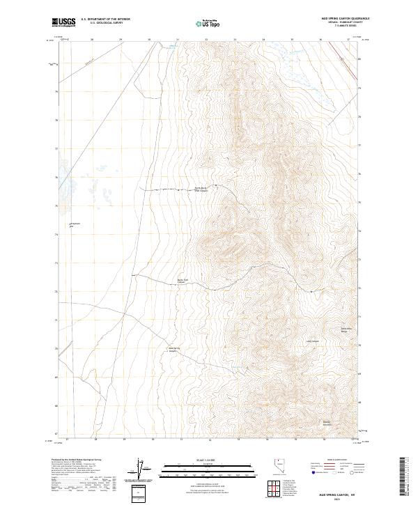
2021 Map of Mud Spring Canyon
USGS Topo · Published 2021About this map
The Santa Rosa Range and the Bloody Run Hills define this high-desert basin in northern Nevada. This area is characterized by deep drainage systems like Mud Spring Canyon and Long Canyon, which cut through the steep topography toward the open expanse of Daveytown Flat. Water sources in this arid environment are sparse but critical, represented by isolated points like Mud Spring and Sandbank Spring. The layout of the land is further marked by ephemeral waterways such as Tony Cr and Porcupine Cr, which flow during seasonal shifts. Cultural imprints are limited to remote access routes like Sand Pass Rd, illustrating the persistence of rural transit patterns in Humboldt County. The map also traces established paths through the interior, including North Bucks Trail Canyon and Bucks Trail Canyon.
Find a feature on this map
18 named features on this map. Tap any name to fly to it.
Don’t see what you’re looking for? This feature index may not catch every label — zoom into the map to look around manually.
Map Details
Editions of this 2021 Mud Spring Canyon Map
This is the sole edition of this map. No revisions or reprints were ever made.
Other maps of this area

1882 · Paradise
USGS Topo · 1:250,000

1893 · Paradise
USGS Topo · 1:250,000

1955 · McDermitt
USGS Topo · 1:250,000

1958 · Paradise Valley
USGS Topo · 1:62,500

1958 · Awakening Peak
USGS Topo · 1:62,500

1959 · McDermitt
USGS Topo · 1:250,000

1959 · Bliss
USGS Topo · 1:62,500
1982 · Andorno Ranch
USGS Topo · 1:24,000
1982 · Gallagher Flat
USGS Topo · 1:24,000
1982 · Silver State Draw
USGS Topo · 1:24,000