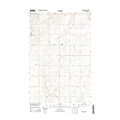
2014 Map of Mud Spring
USGS Topo · Published 2014About this map
Boulder Park and the high plateaus of Douglas County define this landscape, where the agricultural grid meets the deeply incised drainages of the Columbia River basin. The settlement of Mud Spring serves as a central reference point in an area dominated by dryland farming and topographic relief. Large-scale geographic features like McNeil Canyon and Dutch Henry Draw illustrate the erosional patterns of the region, while smaller water sources such as Marion Hill Spring and Willow Spring mark critical points in the arid terrain. The map details a network of section-line roads including Mud Springs Rd NW and Christenson Rd NW, which support the scattered farmsteads and rural infrastructure. Wa-172 provides the primary transit corridor through the southern half of the quadrangle, connecting the remote draws and coulees.
Find a feature on this map
31 named features on this map. Tap any name to fly to it.
Don’t see what you’re looking for? This feature index may not catch every label — zoom into the map to look around manually.
Map Details
Editions of this 2014 Mud Spring Map
This is the sole edition of this map. No revisions or reprints were ever made.
Other maps of this area

1953 · Ritzville
USGS Topo · 1:250,000

1959 · Ritzville
USGS Topo · 1:250,000

1965 · Ritzville
USGS Topo · 1:250,000

1965 · Jameson Lake West
USGS Topo · 1:24,000

1968 · Withrow
USGS Topo · 1:24,000

1968 · Lamoine
USGS Topo · 1:24,000

1968 · Chelan Falls
USGS Topo · 1:24,000

1968 · Chief Joseph Dam
USGS Topo · 1:24,000

1968 · Wells Dam
USGS Topo · 1:24,000
1968 · Azwell
USGS Topo · 1:24,000