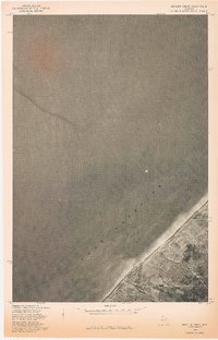
1978 Map of Muggun Creek
USGS Topo · Published 1978About this map
Lake Superior dominates the expanse of this 1978 orthophotoquad, which captures the lake's coastline near the northwestern edge of Michigan's Upper Peninsula. The imagery provides a clear look at the shoreline interface where the deep waters meet the sandy and rocky coastal shelf. Inland, the landscape is defined by the drainage of Muggun Creek, which cuts through the terrain before emptying into the lake. While the majority of the sheet is comprised of open water, the terrestrial portion shows the timbered and rural nature of Houghton County as it appeared in the late 1970s. This advance print allows researchers to see the precise vegetation patterns and land use of the period, overlaid with township and range lines from a 1946 survey. It is a stark representation of the remote Lake Superior shore before further coastal development.
Find a feature on this map
4 named features on this map. Tap any name to fly to it.
Don’t see what you’re looking for? This feature index may not catch every label — zoom into the map to look around manually.
Map Details
Editions of this 1978 Muggun Creek Map
This is the sole edition of this map. No revisions or reprints were ever made.
Other maps of this area

1915 · Houghton
USGS Topo · 1:62,500

1941 · Ahmeek
USGS Topo · 1:31,680

1946 · Hancock
USGS Topo · 1:24,000

1946 · Muggun Creek
USGS Topo · 1:24,000

1946 · Ahmeek
USGS Topo · 1:24,000

1946 · Laurium
USGS Topo · 1:24,000

1947 · Ahmeek
USGS Topo · 1:24,000
1948 · Muggun Creek
USGS Topo · 1:24,000

1948 · Laurium
USGS Topo · 1:24,000

1948 · Hancock
USGS Topo · 1:24,000