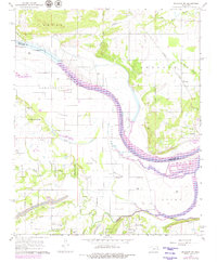
1966 Map of Muldrow SW
USGS Topo · Published 1979About this map
The Arkansas River serves as the central artery through this landscape on the border of Sequoyah and Le Flore counties, its winding course flanked by the fertile lowlands of Tucker Bottom and Cache Bottom. This late 1970s revision, based on earlier surveys, captures a transition in the local economy from the agrarian legacy of the bottomlands to industrial extraction. Multiple Gas Wells are scattered across the terrain, alongside a notable Strip Mine and various quarries, indicating the region's reliance on mineral resources during this era.
Find a feature on this map
33 named features on this map. Tap any name to fly to it.
Don’t see what you’re looking for? This feature index may not catch every label — zoom into the map to look around manually.
Map Details
Editions of this 1966 Muldrow SW Map
3 editions found
Other maps of this area

1900 · Sallisaw
USGS Topo · 1:125,000

1911 · Sallisaw
USGS Topo · 1:125,000

1946 · Fort Smith
USGS Topo · 1:250,000

1965 · Fort Smith
USGS Topo · 1:250,000
1966 · Muldrow
USGS Topo · 1:24,000

1966 · Gans
USGS Topo · 1:24,000

1966 · Muldrow SW
USGS Topo · 1:24,000

1967 · Fort Smith
USGS Topo · 1:250,000
1967 · Sallisaw
USGS Topo · 1:24,000

1967 · Robert S Kerr Dam
USGS Topo · 1:24,000