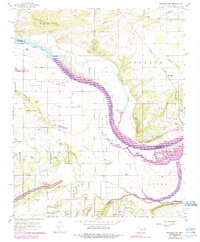
1966 Map of Muldrow SW
USGS Topo · Published 1990About this map
The Arkansas River serves as a dominant boundary in this portion of Le Flore and Sequoyah Counties, carving a path through low-lying alluvial plains like Tucker Bottom, Cache Bottom, and Spiro Bottom. These fertile basins are marked by a network of seasonal drainages and oxbow remnants, including the prominent Tucker Lake and the meandering Cache Creek. The landscape reflects a transition from river-focused agriculture to industrial extraction, evidenced by the numerous Gas Wells and Quarries scattered throughout the higher ground.
Find a feature on this map
31 named features on this map. Tap any name to fly to it.
Don’t see what you’re looking for? This feature index may not catch every label — zoom into the map to look around manually.
Map Details
Editions of this 1966 Muldrow SW Map
3 editions found
Other maps of this area

1900 · Sallisaw
USGS Topo · 1:125,000

1911 · Sallisaw
USGS Topo · 1:125,000

1946 · Fort Smith
USGS Topo · 1:250,000

1965 · Fort Smith
USGS Topo · 1:250,000
1966 · Muldrow
USGS Topo · 1:24,000

1966 · Gans
USGS Topo · 1:24,000

1966 · Muldrow SW
USGS Topo · 1:24,000

1967 · Fort Smith
USGS Topo · 1:250,000
1967 · Sallisaw
USGS Topo · 1:24,000

1967 · Robert S Kerr Dam
USGS Topo · 1:24,000