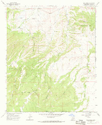
1965 Map of Mule Creek
USGS Topo · Published 1969About this map
Mule Creek sits at the northern edge of this high-desert landscape in Grant County, serving as a focal point for a series of family ranching operations scattered across the foothills of the Mule Mountains. The 1965 field check documents a rural economy tied to the land, where reliable water sources like Mule Spring and Dripping Spring were essential for sustaining livestock. The terrain is defined by deep incisions such as Mule Canyon and Walnut Canyon, which cut through the southwestern expanse of the Gila National Forest. Evidence of much earlier habitation is marked at the Indian Ruins near the eastern boundary, while local history is anchored by the Cem and established holdings like the Larremore Ranch and Harkey Ranch. The map also traces a rugged Jeep Trail winding toward Sunflower Mesa, reflecting the navigational challenges of this borderland territory near the Arizona state line.
Find a feature on this map
33 named features on this map. Tap any name to fly to it.
Don’t see what you’re looking for? This feature index may not catch every label — zoom into the map to look around manually.
Map Details
Editions of this 1965 Mule Creek Map
This is the sole edition of this map. No revisions or reprints were ever made.
Other maps of this area

1910 · Mogollon
USGS Topo · 1:125,000

1912 · Mogollon
USGS Topo · 1:125,000

1913 · Morenci
USGS Topo · 1:125,000

1915 · Morenci
USGS Topo · 1:125,000

1954 · Silver City
USGS Topo · 1:250,000

1954 · Clifton
USGS Topo · 1:250,000

1957 · Clifton
USGS Topo · 1:250,000

1958 · Silver City
USGS Topo · 1:250,000

1958 · Clifton
USGS Topo · 1:250,000

1959 · Steeple Rock
USGS Topo · 1:62,500