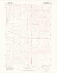
1978 Map of Mule Creek SE
USGS Topo · Published 1979About this map
The Mule Creek Oil Field dominates the western edge of this landscape, marking a period of industrial activity in the arid borderlands where Wyoming and South Dakota meet. The terrain is defined by the dendritic drainage patterns of the North Fork and South Fork, which converge as they flow eastward toward the state line. This 1970s survey captures the intersection of ranching and resource extraction, with features like Bull Pasture Well and a Gravel Pit scattered across the high plains. Water management is critical in this environment, evidenced by the presence of Childers Dam and various unnamed stock wells. The sparse settlement of Cottonwood sits in the southwest, while the Black Hills Meridian provides a key surveying reference point for the high, rolling divides between the Moss and Agate Creek valleys.
Find a feature on this map
15 named features on this map. Tap any name to fly to it.
Don’t see what you’re looking for? This feature index may not catch every label — zoom into the map to look around manually.
Map Details
Editions of this 1978 Mule Creek SE Map
This is the sole edition of this map. No revisions or reprints were ever made.
Other maps of this area

1902 · Edgemont
USGS Topo · 1:125,000

1950 · Edgemont SW
USGS Topo · 1:24,000

1950 · Burdock
USGS Topo · 1:24,000

1951 · Twentyone Divide
USGS Topo · 1:24,000

1955 · Hot Springs
USGS Topo · 1:250,000

1955 · Newcastle
USGS Topo · 1:250,000

1958 · Newcastle
USGS Topo · 1:250,000

1978 · Riverview
USGS Topo · 1:24,000

1978 · Mule Creek
USGS Topo · 1:24,000

1978 · Coffee Flats
USGS Topo · 1:24,000