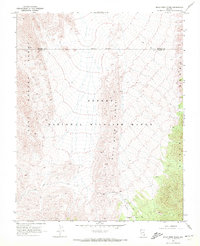
1969 Map of Mule Deer Ridge
USGS Topo · Published 1972About this map
The Desert National Wildlife Range dominates this late-1960s survey of the high Mojave landscape, marking the transition between the East Desert Range and the Sheep Range. This area of Southern Nevada was mapped just as modern conservation boundaries were being formalized, as evidenced by the Indefinite Boundary running between Lincoln and Clark counties. The terrain is defined by the prominent Mule Deer Ridge spine and the depressions of Sheep Basin. Human traces are sparse and localized, limited to a few ruins and a corral located on the eastern slopes. Transportation in this high desert environment is restricted to primitive routes such as the Dead Horse Trail and various unnamed Jeep Trails, which provide the only access through the steep-walled canyons and ridges.
Find a feature on this map
11 named features on this map. Tap any name to fly to it.
Don’t see what you’re looking for? This feature index may not catch every label — zoom into the map to look around manually.
Map Details
Editions of this 1969 Mule Deer Ridge Map
2 editions found
Other maps of this area

1907 · Las Vegas
USGS Topo · 1:250,000

1908 · Las Vegas
USGS Topo · 1:250,000

1945 · Sheep Range
USGS Topo · 1:125,000

1954 · Las Vegas
USGS Topo · 1:250,000

1957 · Las Vegas
USGS Topo · 1:250,000

1959 · Las Vegas
USGS Topo · 1:250,000

1960 · Hayford Peak
USGS Topo · 1:62,500

1962 · Las Vegas
USGS Topo · 1:250,000
1969 · Mule Deer Ridge SE
USGS Topo · 1:24,000
1969 · Mule Deer Ridge NW
USGS Topo · 1:24,000