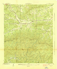
1938 Map of Mulky Gap
USGS Topo · Published 1938About this map
Youngcane and the smaller settlement of Rugby serve as the primary community hubs in this 1938 survey of northern Georgia. The landscape is defined by the mountain ridges of the Chattahoochee National Forest, where civil infrastructure and forest management intersect. Notable landmarks include the C.C.C. Camp No F 12 and the Toccoa Forest Experiment Station, which highlight the federal conservation and labor programs active during the late Depression era.
Find a feature on this map
126 named features on this map. Tap any name to fly to it.
Don’t see what you’re looking for? This feature index may not catch every label — zoom into the map to look around manually.
Map Details
Editions of this 1938 Mulky Gap Map
4 editions found
Other maps of this area

1886 · Dahlonega
USGS Topo · 1:125,000

1888 · Ellijay
USGS Topo · 1:125,000

1892 · Dahlonega
USGS Topo · 1:125,000

1892 · Ellijay
USGS Topo · 1:125,000

1896 · Dahlonega
USGS Topo · 1:125,000

1898 · Ellijay
USGS Topo · 1:125,000

1903 · Dahlonega
USGS Topo · 1:125,000

1911 · Ellijay
USGS Topo · 1:125,000

1935 · Coosa Bald
USGS Topo · 1:24,000

1935 · Ivylog
USGS Topo · 1:24,000