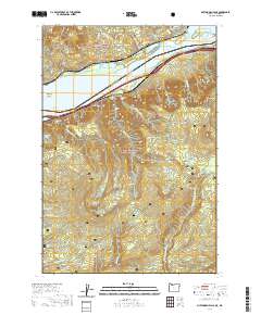
2020 Map of Multnomah Falls
USGS Topo · Published 2020About this map
The Columbia River carves a deep path through this section of the Gorge, separating the riverfront settlements of Warrendale, Dodson, and Skamania. This landscape is defined by the sharp transition from the water's edge to the high peaks of the Mount Hood National Forest and Gifford Pinchot National Forest. Along the southern shore, a dense network of water features emerges from the steep terrain, including Oneonta Falls, Horsetail Falls, and the notable Oneonta Tunnel 1759.
Find a feature on this map
54 named features on this map. Tap any name to fly to it.
Don’t see what you’re looking for? This feature index may not catch every label — zoom into the map to look around manually.
Map Details
Editions of this 2020 Multnomah Falls Map
This is the sole edition of this map. No revisions or reprints were ever made.
Other maps of this area

1916 · Estacada
USGS Topo · 1:125,000

1924 · Mount Hood
USGS Topo · 1:125,000

1926 · Hood River
USGS Topo · 1:125,000

1927 · Mount Hood
USGS Topo · 1:125,000

1929 · Hood River
USGS Topo · 1:125,000

1948 · Vancouver
USGS Topo · 1:250,000

1950 · Vancouver
USGS Topo · 1:250,000

1950 · Vancouver
USGS Topo · 1:250,000

1953 · The Dalles
USGS Topo · 1:250,000

1954 · Bridal Veil
USGS Topo · 1:62,500