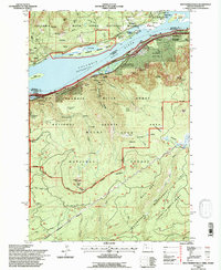
1994 Map of Multnomah Falls
USGS Topo · Published 1997About this map
The Columbia River Broughton Reach dominates this landscape, where the sheer cliffs of the Columbia River Gorge National Scenic Area meet the water. At this point in the mid-1990s, the map reveals the dense concentration of vertical landmarks and waterfalls that define the Oregon side, including the iconic Multnomah Falls, Oneonta Falls, and Horsetail Falls. On the Washington shore, the Gifford Pinchot National Forest rises toward Archer Mtn, while the river itself is dotted with features like Pierce Island and the Franz Lake National Wildlife Refuge. The south end of the map is largely restricted, covering the Bull Run Watershed Management Unit, a critical resource area protected from public access. Small communities like Warrendale and Dodson cling to the narrow corridor between the mountains and the river, marking the path of the historic highway and rail lines.
Find a feature on this map
54 named features on this map. Tap any name to fly to it.
Don’t see what you’re looking for? This feature index may not catch every label — zoom into the map to look around manually.
Map Details
Editions of this 1994 Multnomah Falls Map
This is the sole edition of this map. No revisions or reprints were ever made.
Other maps of this area

1916 · Estacada
USGS Topo · 1:125,000

1924 · Mount Hood
USGS Topo · 1:125,000

1926 · Hood River
USGS Topo · 1:125,000

1927 · Mount Hood
USGS Topo · 1:125,000

1929 · Hood River
USGS Topo · 1:125,000

1948 · Vancouver
USGS Topo · 1:250,000

1950 · Vancouver
USGS Topo · 1:250,000

1950 · Vancouver
USGS Topo · 1:250,000

1953 · The Dalles
USGS Topo · 1:250,000

1954 · Bridal Veil
USGS Topo · 1:62,500