
Loading...
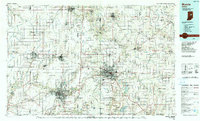
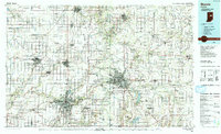
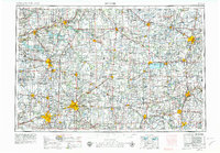
Loading map...1986 Map of Muncie
USGS Topo · Published 1986About this map
Muncie and Anderson serve as the primary urban anchors in this mid-1980s look at East Central Indiana. The landscape is defined by the corridors of the White River and Mississinewa River, alongside significant water features like the Prairie Creek Reservoir. The mapping details the industrial and academic foundations of the region, including Anderson College and Taylor Univ in Upland.
Find a feature on this map
193 named features on this map. Tap any name to fly to it.
Don’t see what you’re looking for? This feature index may not catch every label — zoom into the map to look around manually.
Map Details
Date Portrayed1986
Date Published1986
PublisherU.S. Geological Survey
Map TypeTopographic
Scale1:100,000
Physical Dimensions40 x 24.1 inches
Editions of this 1986 Muncie Map
3 editions found
Historical Maps of Fishers Through Time
3 maps found

Featured Locations
Source Details
SourceU.S. Geological Survey
CopyrightPublic Domain